
Lake Facts
| Johnson/Reeves | |
|---|---|
| DNR ID/ Becker No | Johnson MN03-0374-01 / 374A Reeves- 03-0374-02 / 374B |
| Township(s) | Lake View |
| Lake Classification | Natural Environment |
| Ordinary High-Waterline (OHW) | N/A (Contact MN DNR or PRWD) |
| Size | 219.6 Acres (Johnson) 146.6 Acres (Reeves) |
| Shoreline Length | 3.37 miles (Johnson) 3.44 miles (Reeves) |
| Maximum Depth | 30 Ft (Johnson) 43 Ft (Reeves) |
| Watershed Area | 4576 Acres |
| Impairment Listings | none |
| Common Fish Species | Black crappie, Bluegill, Northern pike, Pumpkinseed, Walleye |
| Invasive Species | None known |
| Public Access/Beaches | none |
| Land Use | 7.3% Open Water 3.3% Developed 9.3% Wetlands 5.2% Cultivated Crops 49.4% Forest 25.5% Grassland |
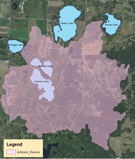
Map
Lake Description & Overview
Johnson and Reeves Lake are both moderately developed, natural environment lakes located south of the City of Detroit Lakes. The two lakes sit north and south relative to each other and are connected via a natural channel on their east side. A prominent wetland fringe surrounds both lakes, uprooted portions of wetland vegetation often detach and move around the lakes by wind and water currents. The channel between the two lakes sometimes becomes blocked by floating bogs, making watercraft passage between the two impossible. Johnson lake lies to the south and is larger in size than Reeves. Johnson and Reeves have similar littoral areas that are 63% and 61% of the lake surface area, respectively.
Water quality has remained stable over the last 20 year period with average clarity of 9 ft on Johnson Lake and 10 ft on Reeves Lake. Total phosphorus levels are also stable on the two lakes, averaging 26 ppb and 27 ppb. Both lakes are considered mesotrophic with moderately clear water. Both lakes do stratify in the summer months, developing an anoxic layer below 4-5 meters (13-16 feet).
The primary source of surface water input to the lake is stormwater runoff from the large drainage area of 4,576 acres. There is a small amount of water that travels via wetland stream from Abbey Lake to the north into Reeves. Reeves also outlets via a wetland stream to Nottage Lake. Groundwater interactions also play a prominent role in the water budget.
Residential development is located on the peninsula which extends between the two lakes from the west. There is also a small campground located on that peninsula, which contains the only boat access to the lake (private access). In recent years, there have been several residential homes constructed on the north and east side of Reeves Lake. Due to the extensive wetland fringe on the lake, only a few locations allow lake access from riparian properties. In some locations, where the wetland fringe is not as prominent, access to the lake has been obtained by removing portions of the wetland vegetation.
Water Quality
Johnson
Reeves
Learn More
DNR Lakefinder
Get information on water levels, fish stocking, and water clarity for Johnson and Reeves.
MPCA Surface Water Data
Find historical lake and stream water quality data for Johnson and Reeves.
Goals
Short Term Goals – Year 2025
- Maintain a 5-year mean summer phosphorus concentration at or below 30 μg/L
- Maintain mean summer Secchi depth no less than 8 ft
Long Range Goals – Year 2035
- Maintain a 5-year mean summer phosphorus concentration at or below 30 μg/L ± 4%
- Maintain mean summer Secchi depth no less than 8 ft
Studies & Surveys
Future Surveys as part of 2020-2030 Monitoring Plan
Water Quality- 2029
Shoreline Survey – 2025
Past Surveys
Water Quality
(Johnson) 1998, 1999, 2000, 2001, 2004, 2005, 2006, 2007, 2008, 2009, 2014, 2015, 2016, 2019.
(Reeves) 2001, 2002, 2004, 2005, 2007, 2008, 2014, 2016, 2019
Shoreline Survey (Johnson & Reeves) – 2004, 2010, 2020
For more studies and surveys, see the Small Lakes Water Management Area.