
Lake Facts
| Meadow | |
|---|---|
| DNR ID/ Becker No | MN 03-371-00/371 |
| Township(s) | Lake View |
| Lake Classification | General Development |
| Ordinary High-Waterline (OHW) | Not Recorded (NGVD29) |
| Size | 71 Acres |
| Maximum Depth | 72 ft. |
| Watershed Area | 244 Acres |
| Impairment Listings | Mercury |
| Common Fish Species | Black Crappie, Bluegill, Green Sunfish, Largemouth Bass, Northern Pike, Walleye |
| Invasive Species | None known |
| Public Access/Beaches | None |
| Land Use | 26% Open Water 5.8% Developed 10.3% Wetlands 21.8% Cultivated Crops 18.3% Forest 17.8% Grassland |
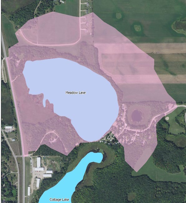
Map
Lake Description & Overview
Meadow is located approximately 4.5-miles SW of the City of Detroit Lakes. Despite its relatively small size, the lake is quite deep, reaching a maximum depth of 72 feet.
Located in the upper part of the Lake Melissa watershed, Meadow has no surface water inlet and is recharged primarily by groundwater interaction and some surface water runoff. There is no true outlet to the lake, however, there is a culvert below Highway 59 that connects Meadow to a wetland and another culvert below CSAH 17 that connects the wetland to Lake Melissa.
Attempts were made by the MN DNR between 1987 through 2009 to regularly stock Rainbow and Brown Trout, however this had limited success. The MN DNR also began stocking walleye in 2010, however, further study found that the lake best supports Largemouth Bass, Bluegill, Crappie, and Northern pike population, so stocking efforts ceased. Because the lake is deep enough to support both warm and cold fisheries, there is a small population remaining of Trout and Cisco (Tullibee).
There are three residential homes on the western shoreline and a campground located on southeast portion. There is some agricultural (row crop) activity to the north of the lake that is separated from the lake by a forested buffer, 150-300 feet wide. Emergent vegetation is present along most of the shoreline except for about 1000 feet near the campground area, which may have been removed for the installation of a sand beach and docking area. There is moderate macrophyte growth in the littoral area of the lake (<15 ft). Lake depths begin to drop sharply about 150-250 feet offshore, where plant growth becomes much more limited.
The District has monitored Meadow Lake since 1999 and the water quality has always been good. Currently the lake is sampled for both chemistry and clarity every three years. The water quality is stable with a 10-year average clarity of 16.5 and total phosphorus concentration of 14 ppb.
Water Quality
Meadow
Learn More
DNR Lakefinder
Get information on water levels, fish stocking, and water clarity for Meadow.
MPCA Surface Water Data
Find historical lake and stream water quality data for Meadow.
Goals
Short Term Goals – Year 2025
- Maintain a 5-year mean summer phosphorus concentration at or below 17 μg/L ± 4%
- Maintain mean summer Secchi depth no less than 15 ft
Long Range Goals – Year 2035
- Maintain a 5-year mean summer phosphorus concentration at or below 17 μg/L ± 4%
- Maintain mean summer Secchi depth no less than 15 ft
Studies & Surveys
Future Surveys as part of 2020-2030 Monitoring Plan
Water Quality- 2025
Vegetation Survey – 2027
Shoreline Survey – 2025
Past Surveys
Water Quality – 1999-2002, 2004, 2006, 2009, 2014, 2017, 2020
Shoreline Survey – 1997, 2004, 2010, 2020
Vegetation Survey – 2022
For more studies and surveys, see the Small Lakes Water Management Area.