Water Management Rules
The District’s Water Management Rules requires property owners to obtain a permit for certain actions:
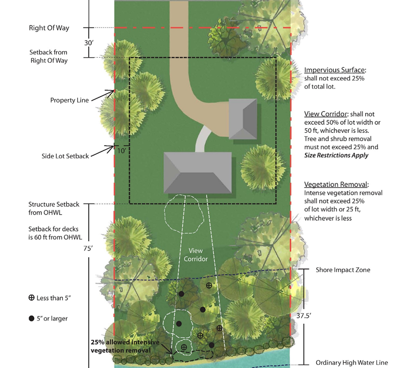
A. Near Shore Actions – alterations to land, impervious surface, or vegetation within Shore Impact Zone, Bluff Impact Zone and Steep Slopes within the Shoreland District.
Actions cannot increase runoff rate or increase nutrient runoff to the waterbody. Natural shoreline topography is to be maintained. Erosion prevention and sediment control plans and practices are required for projects.
-
- Shoreline alterations (installation, repair or replacement of shoreline erosion management practices)
- Vegetation alterations (shoreline buffers; trees, shrubs, ground cover alterations, landscaping)
- Ice Pressure Ridge repairs
- Beach or Perched Sand Blanket
- Structures, Impervious surfaces (sidewalks, lake access paths, stairs, landings, accessory structures)
- Retaining walls (installation, repair, or replacement within in Shore Impact or Bluff Impact Zones)
- Land Alterations (landscaping projects, grade changes, fill placement)
- Shoreline alterations (installation, repair or replacement of shoreline erosion management practices)
B. Stormwater management plans are required for controlling runoff rates, nutrients, and sediments for Impervious Surface Coverage (total accumulation).
Plans are required for Impervious surface (structures, patios, sidewalks, etc.) lot coverage – including new, additions, or changes to (re-development) resulting in impervious surface lot coverage of:
>25% of impervious surface lot coverage;
>10,000 Square Feet of impervious surface lot coverage within the Shoreland District;
> than 1 acre (43,560 square feet) within the watershed district boundary.
C. Changes stormwater infrastructure, streets, public parking; inlets to waters of the state, bridges, or culverts.
D. Construction or re-construction of a private or public road, highway, street, parking lot, or pubic water access.
E. Subdivisions, plats, developments based on certified surveys, or planned unit developments (PUD’s).
F. De-watering of groundwater which discharges to waters of the state.
G. Any proposed work or modification of a Public Drainage System (Becker County Ditches 11,12,13, and 14) or any waterways that impact the discharge or the nutrient loads of those systems.
Please stop by our office or communicate with our staff electronically (prwdpermit@arvig.net) or via phone (218-846-0436). We are here to help you with the greatest extent possible.
General Information – Permit Application, Fees, and Plans
(Click on the project tabs – near shore actions, stormwater management , other actions, drainage systems, additional information for more details/instructions)
- Contact the office to discuss your proposed project or send an email to prwdpermit@arvig.net to determine if a District Permit is required.
- Schedule a site visit to review your ideas, discuss permit requirements and approval process
- Submit Permit Application, Fee, site plan and other required documents.
- Permit Application Form – Permit application requires property owner’s signature. An Authorized Agent Form may be used, however it requires a notarized signature.
- Permit Application/Review Fee. At this time, only checks are accepted as payment.
- Construction Erosion Prevention and Sediment Control Plan (or SWPPP); Construction Erosion and Sediment Control BMP Examples
- Site Plan – Near Shore Alterations Site Plan (Shore Impact Zone)
- Project Maintenance Plan/Agreement (stormwater, vegetative buffers) – Maintenance Agreement-Infiltration Basin, Raingarden – Maintenance Agreement-Dry well/ Infiltration Trench/ French Drain
*** Links for Planting Considerations:
–Vegetation Establishment and Management (BWSR): https://bwsr.state.mn.us/vegetation-establishment-and-management
–Developing a Planting Plan for Spacing (MN DNR): https://www.dnr.state.mn.us/rys/st/plantingplan.html - Other applicable project submittals if required – engineered drawings, plans, calculations (Stantec Technical Memorandum); approvals from other agencies (Becker County, City of Detroit Lakes, MN Dept of Natural Resources, MN Pollution Control Agency, etc.). PRWD staff will provide guidance on required submittals.
If at any point in the process you have questions, please do not hesitate to contact PRWD at: 218-846-0436; prwdpermit@arvig.net; or stop at the office located on the second floor of the Wells Fargo Bank building. (211 Holmes St. West, Suite 201, Detroit Lakes, MN).
Permit Surety
A permit surety may be required of the permit holder or applicant. A surety is a monetary sum (amount set by the Board of Managers, District staff and/or the District engineer after review of the project application or approved permit) provided by the applicant/permittee to the District to ensure the project is completed as designed and in compliance with District Rules. The District returns the money to the applicant/permittee after all permit conditions are met and the project is complete. If the District requires a surety, the applicant/permittee must provide the District the surety amount in the form of a check made out to the Pelican River Watershed District, or a Performance Bond, or Letter of Credit.
Amended Permit
If changes are made to the permitted project plans, the project plan changes must be submitted to the District for review prior to installation or completion occurs. If changes are approved by the District, an amended permit will be issued.
Permit Extension Request
PRWD permits are valid for eighteen (18) months from the date of issuance, unless otherwise suspended or revoked. A six-month extension may be granted, provided the property owner notifies the District via email (prwdpermit@arvig.net) or writing stating the reasons for the extension. Any plan changes and related project documentation must also be submitted with the extension request. The District must receive the extension request at least thirty (30) days prior to the permit’s expiration date.
The protection of natural vegetation in shoreland areas, especially along lakes and streambanks, is critical to maintaining good water quality and wildlife habitat. Good management requires the protection of natural vegetation in shore impact zones, steep slopes and bluff areas. The District’s Water Management Rules help protect our waters, encourages responsible construction/development, and prevents actions that do not protect the public’s interest in healthy shoreland and waters.
- For Near Shore Activities:
- Contact the office to discuss your proposed project or send an email to prwdpermit@arvig.net to determine if a District Permit is required.
- Schedule a site visit to review your ideas, discuss permit requirements and approval process
- Submit Permit Application, Fee, site plan and other required documents.
- Permit Application Form – Permit application requires property owner’s signature. An Authorized Agent Form may be used, however it requires a notarized signature.
- Permit Application/Review Fee. At this time, only checks are accepted as payment.
- Construction Erosion Prevention and Sediment Control Plan (or SWPPP); Construction Erosion and Sediment Control BMP Examples
- Site Plan – Near Shore Alterations Site Plan (Shore Impact Zone) – Impervious Surface Site Plan and Impervious Surface Coverage Worksheet
- Project Maintenance Plan/Agreement (stormwater, vegetative buffers) – Maintenance Agreement-Infiltration Basin, Raingarden – Maintenance Agreement-Dry well/ Infiltration Trench/ French Drain
- Other applicable project submittals if required – engineered drawings, plans, calculations (Stantec Technical Memorandum); approvals from other agencies (Becker County, City of Detroit Lakes, MN Dept of Natural Resources, MN Pollution Control Agency, etc.). PRWD staff will provide guidance on required submittals.
Do you need a PRWD Permit?
(Click on the applicable dropdown boxes below)
Shoreline Erosion Repair
Yes! a permit is needed for this action. Stabilization actions must be in accordance with applicable State of MN DNR, City of Detroit Lakes, Becker County, and Pelican River Watershed District regulations and guidelines.
Types of Shoreline Stabilization
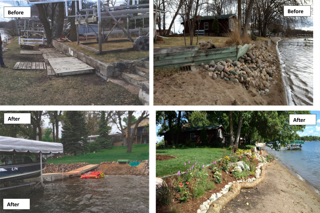
- Re-vegetation or bioengineering using native plant material (i.e., trees, shrubs, seeding, plant plugs). Using native plantings for shoreline and bank stabilization is a cost-effective approach to address shoreline erosion. Where re-planting alone is not sufficient to stop erosion, a bioengineering (soft structures) approach may be more appropriate. Natural vegetation should be left intact to the maximum extent practicable, however regrading and replanting of slopes may be necessary. Where unstable banks are present, the slopes should be replanted with native, non-invasive trees, shrubs, and ground cover. Steep slopes may require the use of jute or turf reinforcement mats to prepare the site to readily accept native plants and/or dormant woody plant cuttings called “live stakes.” Many low-growing species are available that will not block waterfront views. Some species of common shrubs have roots that extend deep into the soil, helping to keep the soil and shoreline together. When damage does occur to a natural shoreline, native plants can easily re-establish and protect the shoreline. Soft structure techniques use a combination of plants, natural materials such as fiber coir logs, biodegradable landscape fabric, coconut fiber blankets, live stakes (e.g., cuttings from species like willow), and brush bundles (i.e., branches from live woody plants) and may include regrading and replanting of slopes. This design creates a natural appearance, provides habitat for fish and wildlife, and leads to long-term stabilization of a shoreline, reducing the need for future work. Contact Becker County Soil and Water Conservation District or the local greenhouse for plant species suggestions.
- Bio-armor (combination of native plants and extra shoreline support with natural rock rip-rap):
Where native plantings or plant bioengineering techniques are not suitable for the site, then the use bio-armoring (combination of native plant material and natural rock riprap) is appropriate. Areas along the shore needing extra support can benefit from the use of natural rock rip-rap. Rip-rap is placed at the base or toe of a slope to the smallest possible footprint necessary, following the natural contour of the shoreline, in combination with vegetative stabilization techniques used higher up the bank. A layer of clean crushed gravel placed behind the rock will help prevent further loss of sediment from the bank. Vegetation planted among the rocks and at the top of the bank will greatly increase the long-term stability of the shoreline from ice and wave action, provide a buffer to filter rainwater, and provide wildlife habitat.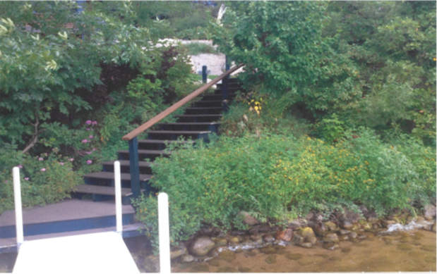
- Natural rock rip-rap: Rip-rap is a layer of natural rock placed along the shoreline to prevent shoreline erosion from wave action (not placed for “cosmetic” reasons). Installation of riprap is allowed only where there is a demonstrated need to stop existing erosion or to restore an eroded shoreline (MN DNR).
-
- The use of riprap in a project should be the minimal impact solution, must not cover emergent vegetation [unless authorized by an aquatic plant management permit from MN DNR Fisheries], must conform to the natural contour/alignment of the shoreline, and not obstruct navigation or flow of water.
- Only natural rock (cannot average less than six (6) inches in diameter or more than thirty (30) inches in diameter) may be used that is free from organic material, soil, clay, debris, trash or any other material that may cause siltation or pollution. Concrete is not allowed (MN DNR).
- Riprap will consist of coarse stones that are randomly and loosely placed. A row of boulders at the water’s edge, uniform rock size or arrangement (panning or stacking) is not considered natural rip rap. (MN DNR).
- A filter of crushed rock/gravel, or filter fabric material must be placed underneath the rock. Where organic soils may present an issue for soil loss, geotextile filter fabric may be used (MN DNR)
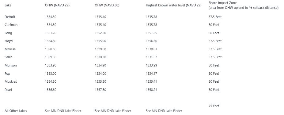
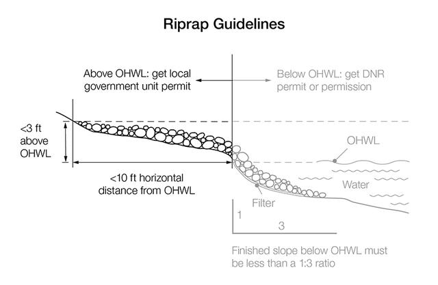
- The finished slope does exceed three feet horizontal to one foot vertical beneath the ordinary high-water level; and
- The height of the riprap extends no higher than three feet above the ordinary high-water level, or one foot above the highest known water level, or one foot above evidence of erosion, whichever is less; and extend no more than 6 feet lakeward of the OHW (City of DL Shoreland Ordinance)
- For rip-rap projects greater than 200 linear feet of shoreline, a MN DNR permit is also required.
-
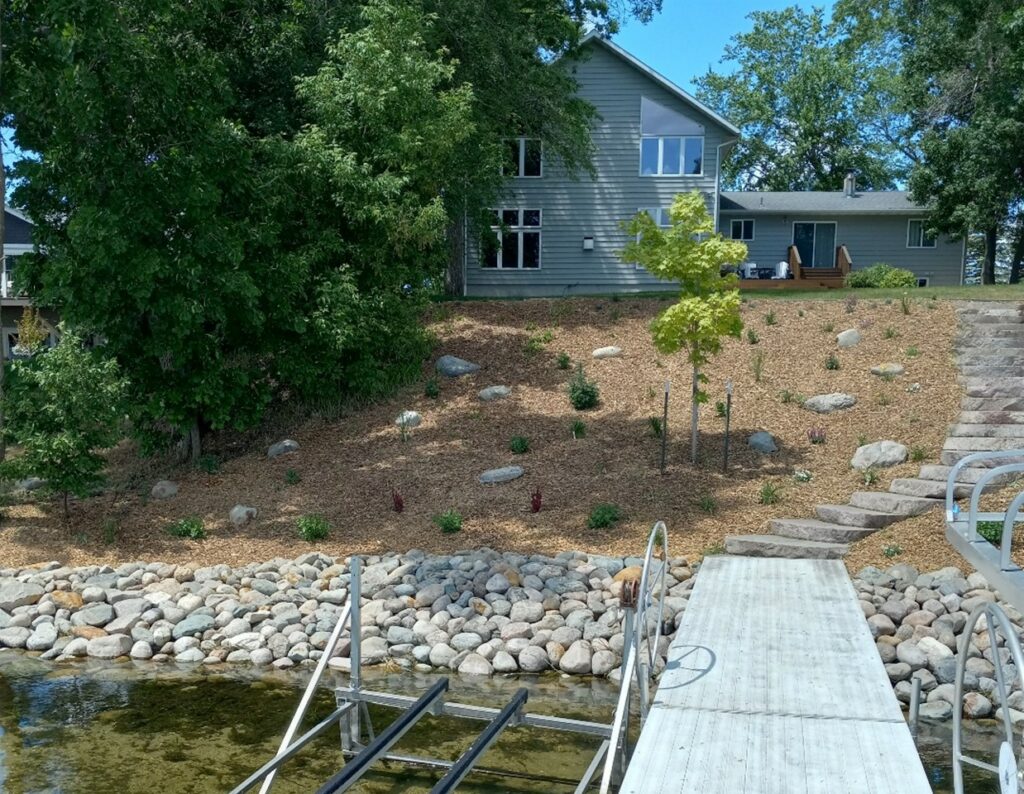
Vegetation Alterations: trees, shrubs, groundcover, shoreline buffers, landscaping
Yes! A permit is required for vegetation alterations (trees, shrubs, ground cover, shoreline buffers, landscaping) , installation of landscape features, vegetative buffers, and for removal of dead, diseased, or unsafe trees within the Shore or Bluff Impact Zones, or on steep slopes within the Shoreland Zone. If you are interested in a shoreline buffer contact Becker County Soil and Water Conservation District as there may be cost-share grants available.
Be aware there are limitations with pruning and trimming of trees, shrubs and groundcover in the protected shore impact zone and on steep slopes such as to provide a view to the water from the principal dwelling and to accommodate the placement of stairways and landings, access paths, and beach and watercraft access areas as allowed for in City of DL or Becker County Shoreland Ordinances.
Tree Removal. Tree removal should be a last resort option. Please contact the District for assistance in determining whether a tree is dead, diseased, or unsafe (structures, powerlines, storm damaged). For each tree permitted to be removed, it will be replaced with a native tree species on a 1:1 basis. Stumps may be ground down flush to the ground; below-ground roots must be left in place, as they provide stability on fragile lakeshores. Tree replacement will be appropriate native species and 1.5″ – 2.0″ trunk caliper size.
Removal of tree and/or stumps is considered excavation and will be permitted only if their removal is required for the legal placement of lake access paths or structures where the removal cannot be avoided; each tree/stump removed will be replaced with native tree species on a 2:1 basis. Erosion and Sediment control best management practices are required to stabilize the affected project area. For a tree in a problematic location and/or not an appropriate species, replacement will be on a 3:1 basis.
If there is no structure at risk, consider letting the tree fall on its own – dead trees are wonderful habitat. Trees and deep-rooted vegetation also hold your valuable shoreline together and prevent erosion. Natural shoreline vegetation increases habitat for loons, fish and songbirds, while discouraging use by geese who prefer mowed lawns and sand blankets.
Violations: Within the Shore Impact Zone, tree removal violations will be mitigated with native tree species on a 3:1 basis (3 trees planted for each tree removed).
No permit is required for trimming, pruning, and thinning of branches or limbs to protect structures, maintain clearances, or provide limited view corridors, however such actions may not result in adversely affecting the health of the tree.
Bluff Impact Zone – Alterations to land or vegetation within a Bluff Impact Zone is not allowed. The District may require a geotechnical report to verify the stability of the bluff. Schedule a site visit (218-846-0436 or prwdpermit@arvig.net) to review the site.
Vegetation Alterations. Any proposed permitted action must prepare a permanent vegetation plan to addresses the following:
- Must preserve or establish and maintain full tree canopy and native ground cover.
- Limited pruning and trimming are allowed to provide filtered views of the lake from the principle dwelling.
- Demonstrates that the action will not create or increase erosion or stormwater runoff from the site.
- Meets all local ordinances
Beach or Perched Sand Blanket
Yes! A PRWD Permit is required for beach or perched sand blankets in the SIZ.
-
-
- The lake bottom must be suitable (hard bottom – sand, gravel) for supporting the material.
- The maximum size cannot be greater the 50 linear feet, (or ½ width of the lot, whichever is less), by 10 feet wide. The depth of sand on the beach will not exceed six (6) inches.
- Use only clean, inorganic sand or gravel – free of nutrients and pollutants (no silt, loam, clay – these cause water quality problems if they enter the lake).
- Designs will incorporate a method for diverting surface water runoff around the beach area to prevent erosion of sand into the lake during rain events. Examples of diversions include installation of a low berm along the backside/landward of the sand blanket or where high volume of runoff is occurring, a combination of swales, raingardens or berms may need to be considered. It is far more cost-effective (and beneficial to the lake) to incorporate sound stormwater diversions in the initial design phases than having to reconstruct beaches and replenish beach sand in the future.
- Beach sand blankets are in a location that will not readily wash or erode into the waterbody. Shorelines with slopes greater than 5% percent, on emergent vegetation or wetland areas (emergent, marshy shorelines) are not suitable for a sand blanket. A perched sand blanket may be installed if near shore topography is suitable.
- Non-biodegradable fabric under the sand blanket is not allowed.
- Beach Replenishment: Replenishment of sand may be repeated once at the same location but may not exceed the amount of sand and dimensions of the original sand blanket (MN DNR). More than one sand replenishment requires a permit from the MN DNR.
-
Perched Beach Area
If a shoreline does not have a natural beach, this is a clear indication that natural erosive forces (wind, water) will work to destroy any sand beach constructed on site. Construction of a beach in a “perched” position helps prevent the erosion of sand into the water and requires less maintenance by the property owner.
-
-
- placed on a shoreline location where the least amount of tree, vegetation, rock, or soil alteration occurs.
- a “perched beach” must have little slope and be located entirely out of the water, above and landward of the OHW.
-
For more information, see the Resource Library.
![]()
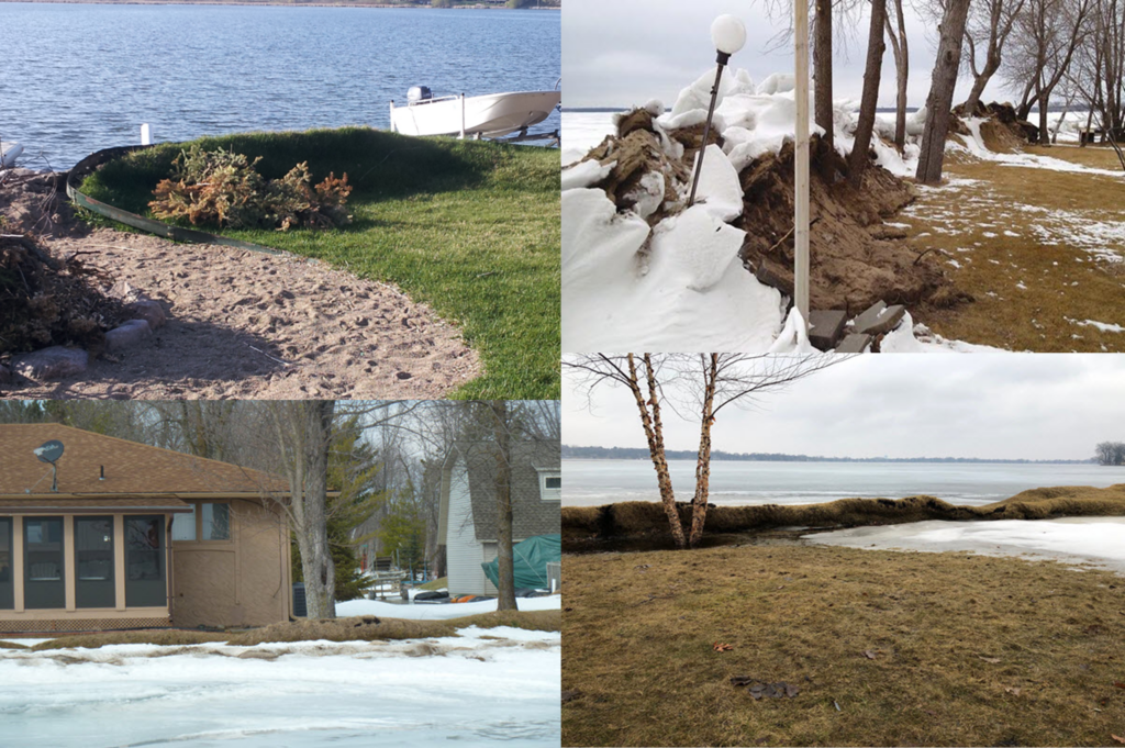
Shoreline Pressure Ridge Repair
Yes! Repair of a shoreline pressure ridge that was damaged by “ice push/action” within the last year (previous winter season) may be repaired with an approved PRWD Permit. Minnesota DNR, City of Detroit Lakes, and Becker County may also regulate alterations to ice ridges. For more information, please review the DNR website , or see the Resource Library.
PRWD uses the following criteria to approve shoreline pressure ridge repair permits:
-
- Modifications or repairs are only allowed on ice pressure ridges that experienced recent damage from ice action within the last year;
- A ridge of no less than eight (8) inches must be maintained parallel to the shore or ice ridge repaired to previous height (whichever is higher). The 8-inch difference shall be measured between the ridge top and 3 feet landward of the ridge;
- All ice ridge material that is composed of muck, clay, or organic sediment cannot be put in the lake and must be placed and stabilized at an upland site above the ordinary high-water level (OHWL);
- All ice ridge material that is composed of sand or gravel may be regraded to conform to the original cross-section and alignment of the lakebed, with a finished surface at or below the ordinary high-water level (OHWL) or it may be removed.
- No additional excavation or replacement fill material occurs on the site;
- All exposed areas are immediately stabilized as needed to prevent erosion and sedimentation;
- A four (4) foot lake access/walkway may be placed on top of the ridge, but not cut through the ridge.
Minnesota DNR, City of Detroit Lakes, and Becker County may also regulate alterations to ice ridges. For more information, please review the DNR website , or see the Resource Library.
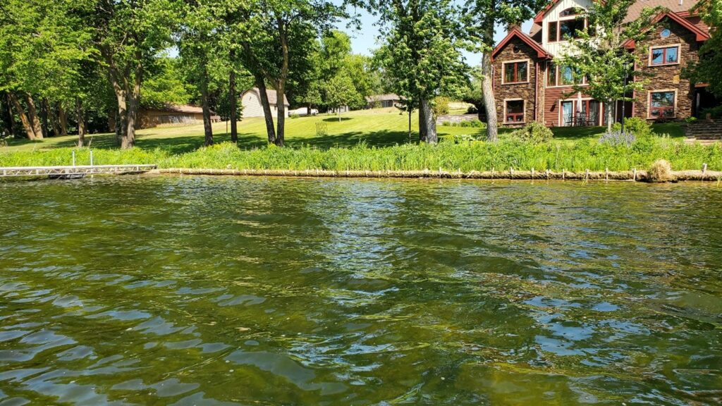
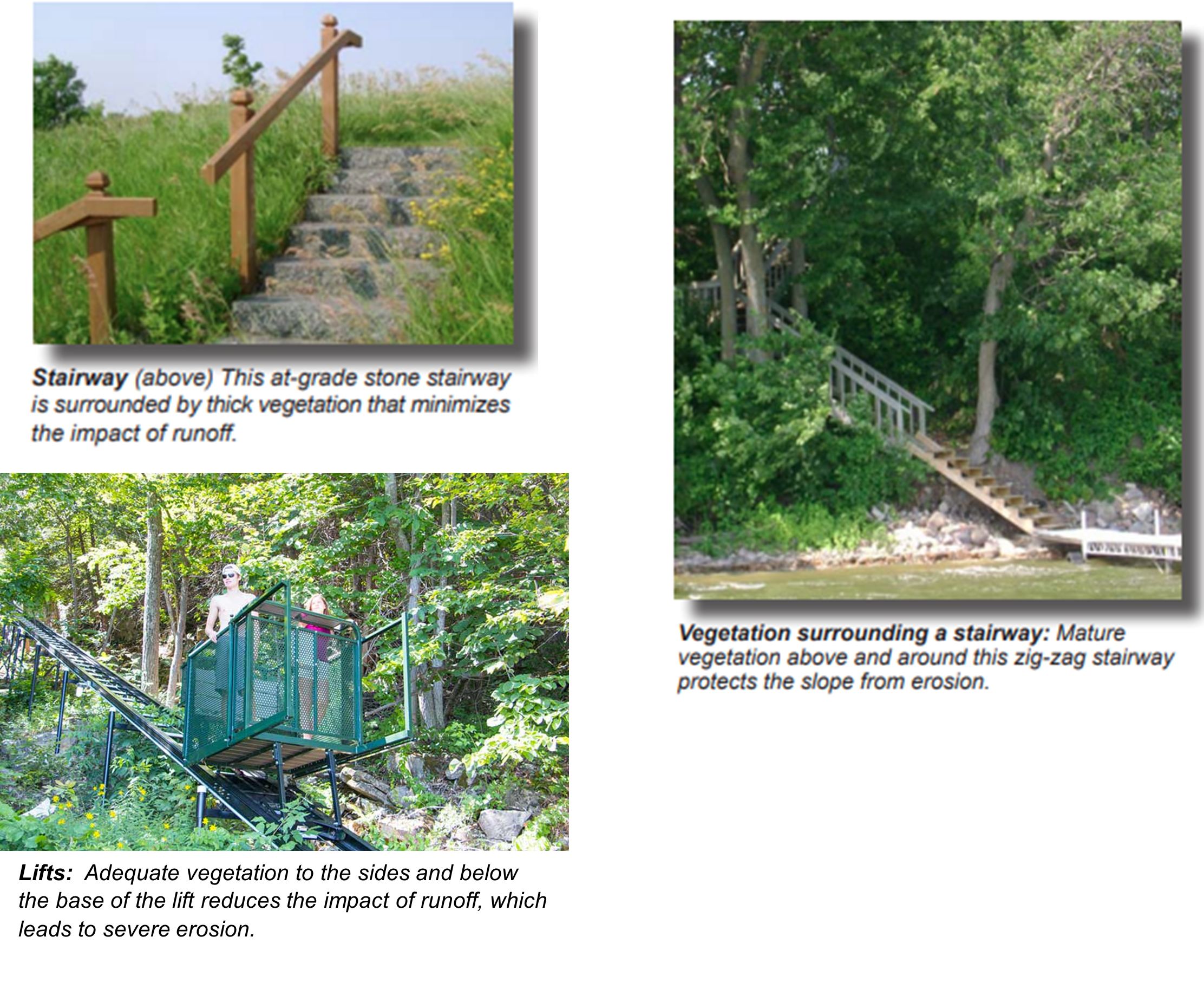
Stairways, Lifts, Landings, Lake Access Walkways, Structures, Impervious Surface
Yes! Installation of stairways, lifts, landings, and lake access walkways will require a permit from the Pelican River Watershed District.
Proposed activity must meet all other local ordinance requirements (City of Detroit Lakes, Becker County). Stormwater from all new and reconstructed impervious surfaces in the shore and bluff impact zones and on steep slopes must be treated following PRWD standards. See the Stormwater Management Section for more information.
For lake access walkways (all projects must also meet City of Detroit Lakes and Becker County Ordinance requirements):
-
-
- One walkway is allowed for lake access at a maximum of 4 feet wide;
- One 32 square-foot landing is allowed along the staircase; Becker County Ordinance allows at the bottom of a steep slope or bluff a 48 square foot landing if the staircase exceeds 10 feet in height.
- Walkways can be built on top of ice ridges, not through;
- New patios or decks are not allowed in the shore impact zone.
-
Land Alterations: Landscaping Projects, Movement of earth (grade changes, fill placement)
Yes! Work conducted the Bluff and Shore Impact Zones or Steep Slopes in the Shoreland District requires a permit from PRWD. These activities may also require a Zoning Permit from Either Becker County or The City of Detroit Lakes. Contact PRWD, Becker County Planning and Zoning, or the City of Detroit Lakes for more information.
Retaining Walls
Yes! Retaining wall construction, repair, replacement within the Shore and Bluff impact zones are allowed only for the purposes of correcting existing shoreline slope instability or erosion and not intended aesthetic purposes or for creating a beach or recreational use area.
Pre-application meeting. Conduct a preliminary on-site meeting with the District Engineer and staff to review existing site conditions and shoreline slope erosion/repair alternatives and options such as bioengineering methods. The property owner and/or contractor may present proposed/preliminary conceptual plans/sketches to the District.
Project Design Plans.
-
-
- Retaining wall designs involving the construction, repair, or replacement in the shore impact zone are required to include a site evaluation and construction plans designed and signed by an appropriate registered professional. The District may require a geotechnical report to review if conditions are suitable for wall construction.
- Retaining wall design plans must comply with accepted engineering principles. The plan must include an analysis which shows that the wall will withstand expected ice and wave action, and earth pressure. The base of the wall must be above the highest known water elevation and the dimensions of the retaining wall are the minimum necessary to control the shoreline slope instability or erosion problem. Design drawings include current profile, evidence of previous profile (if applicable), and proposed profile meeting the slope, width and height standards of MN DNR.
-
NOTE: For waterbodies within the City of Detroit Lakes – Fences & landscape walls are not to be constructed in the shore impact zone (City of DL Shoreland Ordinance).
For more information, see the Resource Library.
Non-Conforming Structures, Variances, and Mitigation
It Depends. Most projects that are granted a variance or conditional use by Becker County or the City of Detroit Lakes for impervious surface lot coverage, structures in the shore impact zone, or for projects requiring on-site mitigation measures (i.e., shoreline buffers, stormwater management practices, plantings) will require a District permit. District permits are approved only after the required approvals (variance, conditional use, or permit) have been granted by local zoning authorities. The District works closely with Becker County and the City of Detroit Lakes and assists in review of mitigation requirements. It is best to contact the District early in the planning phase (218) 846-0436 or email at prwdpermit@arvig.net.
The Pelican River Watershed District issues permits to ensure stormwater runoff from development and infrastructure projects does not negatively impact the District’s lakes, rivers and wetlands. Impervious or paved surfaces generate large volumes of runoff that may contain dirt, bacteria, fertilizers, salt, oil, and trash, all of which contribute to poor water quality in the district. Water quality and stormwater management rules adopted by our Board of Managers govern all PRWD permitting requirements. PRWD requires erosion and sediment control during project construction and installation of Best Management Practices (BMPs) to treat runoff after construction.
Do you need a PRWD Permit?
Residential- Greater than 25% Impervious Surface Lot Coverage but Less than 10,000 Square Feet Total Impervious Surface Lot Coverage within the Shoreland District
Yes! A permit is required for a residential project with greater than 25% impervious surface lot coverage, but less than a total of 10,000 square feet of impervious surface lot coverage (existing and new) within the Shoreland District. For existing and redeveloped sites, in certain circumstances the runoff treatment area requirement may be different from undeveloped sites. Becker County and the City of Detroit Lakes Shoreland Ordinances govern impervious surface coverage allowances, approvals, and mitigation requirements. Approval conditions must first be obtained from these entities prior to the District issuing a stormwater management permit. It is best to contact the District at 218-846-0436 or email prwdpermit@arvig.net to review your project in the early planning stages and to assist with agency requirement coordination.
Residential Stormwater Permit Application Checklist
- Permit Application and applicable fee
- A Stormwater Management Plan to treat and control runoff, Post Construction Maintenance Plan for installed practices, and a Erosion Prevention and Sediment Control Plan for constructing the project.
Controlling and Treating Runoff on your property
On a residential project with greater than 25% impervious surface lot coverage, but less than a total of 10,000 square feet of impervious surface lot coverage (existing and new) within the Shoreland District, the runoff treatment practice will be sized to capture a minimum of 2.2” runoff, and will not require rate-control calculations.
Step One: I have been granted approval by Becker County or the the City of Detroit Lakes for my project. My lot has greater than 25% of total impervious surface lot coverage (new, additions, existing/remaining) but less than 10,000 square feet of impervious surface lot coverage. I will need a PRWD stormwater management permit for my proposed project.
Step Two: How do I calculate the runoff treatment area needed for my proposed project?
A. New, Undeveloped Site – All new impervious surface area runoff is treated.
B. Existing, Redeveloped Site – All re-constructed impervious surface and additions to existing impervious surface area runoff is treated. Existing impervious surface areas that are not removed or unchanged are exempt from the runoff treatment requirement.
- Example One: A property with existing structures and driveway is re-developed. Lot size is 15,000 SF; 3,750 SF=25% lot coverage. All existing structures and driveway are removed and the entire site will be re-developed with a new home/patio (2,500 SF) and driveway, parking pad, sidewalks (1,500 SF). A permit is required (>25% total impervious surface coverage, but <10,000 square feet of total impervious surface coverage), and all changed, re-developed areas (4,000 SF) will require runoff treatment.
Sizing my Stormwater Treatment Practice: Impervious surface area treated x 2.2″ rainfall / 12″= Volume (in cubic feet) of runoff storage required. 4,000SF x 2.2″ / 12 = 733 cubic feet of storage required.
Note: Practices using rock (underground infiltration practices such as French drains) will need to include an additional calculation. Example: 733 cubic feet of storage is required, however the homeowner is installing an underground infiltration practice (French drain). To compensate for the rock used to fill the practice as follows; 733 / 0.4 = 1832 cubic feet of storage is required. Please contact PRWD to help with your calculations. Check with the City of Detroit Lakes or Becker County Planning and Zoning to see If your project requires a variance, conditional use, or other mitigation measures. Please provide the other governmental agency’s requirements with the permit submittal. - Example Two: A property with existing structures and driveway is adding on to the home. Lot size is 10,000 SF; 2,500 SF=25%. An addition of 500 square feet to an existing home (1200 SF) will be constructed, but no other changes or reconstruction of the driveway, sidewalks, parking pads, and patio (1,000) will be made. A permit is still required (>25% total impervious surface coverage, but <10,000 square feet of total impervious surface coverage) , however, only the changed/addition area (500 SF) will require runoff treatment.
Sizing my Stormwater Treatment Practice: Impervious surface area treated x 2.2″ rainfall / 12″= Volume (in cubic feet) of runoff storage required. 500SF x 2.2″ / 12 = 92 cubic feet of storage required.
Note: Practices using rock (underground infiltration practices such as French drains) will need to include an additional calculation. Example: 92 cubic feet of storage is required, however the homeowner is installing an underground infiltration practice (French drain). To compensate for the rock used to fill the practice as follows; 92 / 0.4 = 230 cubic feet of storage is required. Please contact PRWD to help with your calculations. Check with the City of Detroit Lakes or Becker County Planning and Zoning to see If your project requires a variance, conditional use, or other mitigation measures. Please provide the other governmental agency’s requirements with the permit submittal. - Example Three: A property with existing structures and driveway is removing the home and rebuilding. Lot size is 27,000 square feet; 6,750 SF=25%. The existing home is removed (3,500 SF) and will be reconstructed with a smaller home (3,000 SF), but the driveway (3,000 SF) and unattached garage (1,000 SF) will remain unchanged or will not be reconstructed. A permit is still required (>25% total impervious surface coverage, but <10,000 square feet of total impervious surface coverage), however, only the changed/reconstructed area (3,000 SF) will require runoff treatment.
Sizing my Stormwater Treatment Practice: Impervious surface area treated x 2.2″ rainfall / 12″= Volume (in cubic feet) of runoff storage required. 3,000SF x 2.2″ / 12 = 550 cubic feet of storage required.
Note: Practices using rock (underground infiltration practices such as French drains) will need to include an additional calculation. Example: 550 cubic feet of storage is required, however the homeowner is installing an underground infiltration practice (French drain). To compensate for the rock used to fill the practice as follows; 550 / 0.4 = 1375 cubic feet of storage is required. Please contact PRWD to help with your calculations. Check with the City of Detroit Lakes or Becker County Planning and Zoning to see If your project requires a variance, conditional use, or other mitigation measures. Please provide the other governmental agency’s requirements with the permit submittal.
For additional information on types of infiltration practices that will treat your runoff, refer to the MPCA Stormwater Manual.
Residential- Greater than 10,000 Square Feet Total Impervious Surface Lot Coverage within the Shoreland District
Yes! A permit is required for a residential project with greater than a total of 10,000 square feet of impervious surface lot coverage (existing and new) within the Shoreland District. These sites require an engineered plan, please contact the permitting department at prwdpermit@arvig.net, or (218) 846-0436.
For existing and redeveloped sites, in certain circumstances the runoff treatment area requirement may be different from undeveloped sites. Becker County and the City of Detroit Lakes Shoreland Ordinances govern impervious surface coverage allowances; approvals, mitigation requirements, approval conditions must first be obtained from these entities prior to the District issuing a stormwater management permit. It is best to contact the District at 218-846-0436 or email prwdpermit@arvig.net to review your project in the early planning stages and to assist with agency requirement coordination.
Permit Application Checklist
- Permit Application and applicable fee
- Engineered stormwater management plan, water quality and quantity calculations, grading and sediment control plan (SWPPP), vegetation/planting plant if part of the runoff practice, maintenance agreement per Stantec Technical Memorandum
- Minnesota Stormwater Manual
Commercial- Greater than 10,000 Square Feet or 25% Impervious Surface Lot Coverage within the Shoreland District
Yes! A permit is required for a commercial project with greater than a total of 10,000 square feet or 25% of impervious surface lot coverage (existing and new) within the Shoreland District. These sites require an engineered plan, please contact the permitting department at prwdpermit@arvig.net, or (218) 846-0436.
Permit Application Checklist
- Permit Application and applicable fee
- Engineered stormwater management plan, water quality and quantity calculations, grading and sediment control plan (SWPPP), vegetation/planting plant if part of the runoff practice, maintenance agreement per Stantec Technical Memorandum
- Minnesota Stormwater Manual
Greater than 1 Acre of Impervious Surface Lot Coverage within the District
Yes! A permit is required for a residential project with greater than 1 Acre impervious surface lot coverage (existing and new) within the Pelican River Watershed District. These sites require an engineered plan, please contact the permitting department at prwdpermit@arvig.net or (218) 846-0436.
Permit Application Checklist
- Permit Application and applicable fee
- Engineered stormwater management plan, water quality and quantity calculations, grading and sediment control plan (SWPPP), vegetation/planting plant if part of the runoff practice, maintenance agreement per Stantec Technical Memorandum
- Minnesota Stormwater Manual
New, Additional, or Reconstruction of Private or Public Highways, Roads, Streets, Trails (Linear Projects)
Yes! A permit is required for a linear projects with New, Additional, or Reconstruction of Private or Public Highways, Roads, Streets, and Trails. These sites require an engineered plan, please contact the permitting department at prwdpermit@arvig.net, or (218) 846-0436.
Permit Application Checklist
- Permit Application and applicable fee
- Engineered stormwater management plan, water quality and quantity calculations, grading and sediment control plan (SWPPP), vegetation/planting plant if part of the runoff practice, maintenance agreement per Stantec Technical Memorandum
- Minnesota Stormwater Manual
Subdivisions, Plats, and Planned Unit Developments (PUDs)
Yes! a permit is required for preliminary subdivisions, plats, developments based upon certified survey maps, and planned unit developments and must provide a a stormwater management plan for the proposed impervious surface. Please contact the permitting department at prwdpermit@arvig.net or (218) 846-0436.
Permit Application Checklist
- Permit Application and applicable fee
- Engineered stormwater management plan, water quality and quantity calculations, grading and sediment control plan (SWPPP), vegetation/planting plant if part of the runoff practice, maintenance agreement per Stantec Technical Memorandum
- Minnesota Stormwater Manual
New, Additional, or Reconstruction of Parking Lots, Public Water Accesses, Stormwater Infrastructure
Yes! A permit is required for a project with New, Additional, or Reconstruction of Parking Lots, Public Water Accesses, or Stormwater Infrastructure. These sites require an engineered plan, please contact the permitting department at prwdpermit@arvig.net or (218) 846-0436.
Permit Application Checklist
- Permit Application and applicable fee
- Engineered stormwater management plan, water quality and quantity calculations, grading and sediment control plan (SWPPP), vegetation/planting plant if part of the runoff practice, maintenance agreement per Stantec Technical Memorandum
- Minnesota Stormwater Manual
Do you need a PRWD Permit?
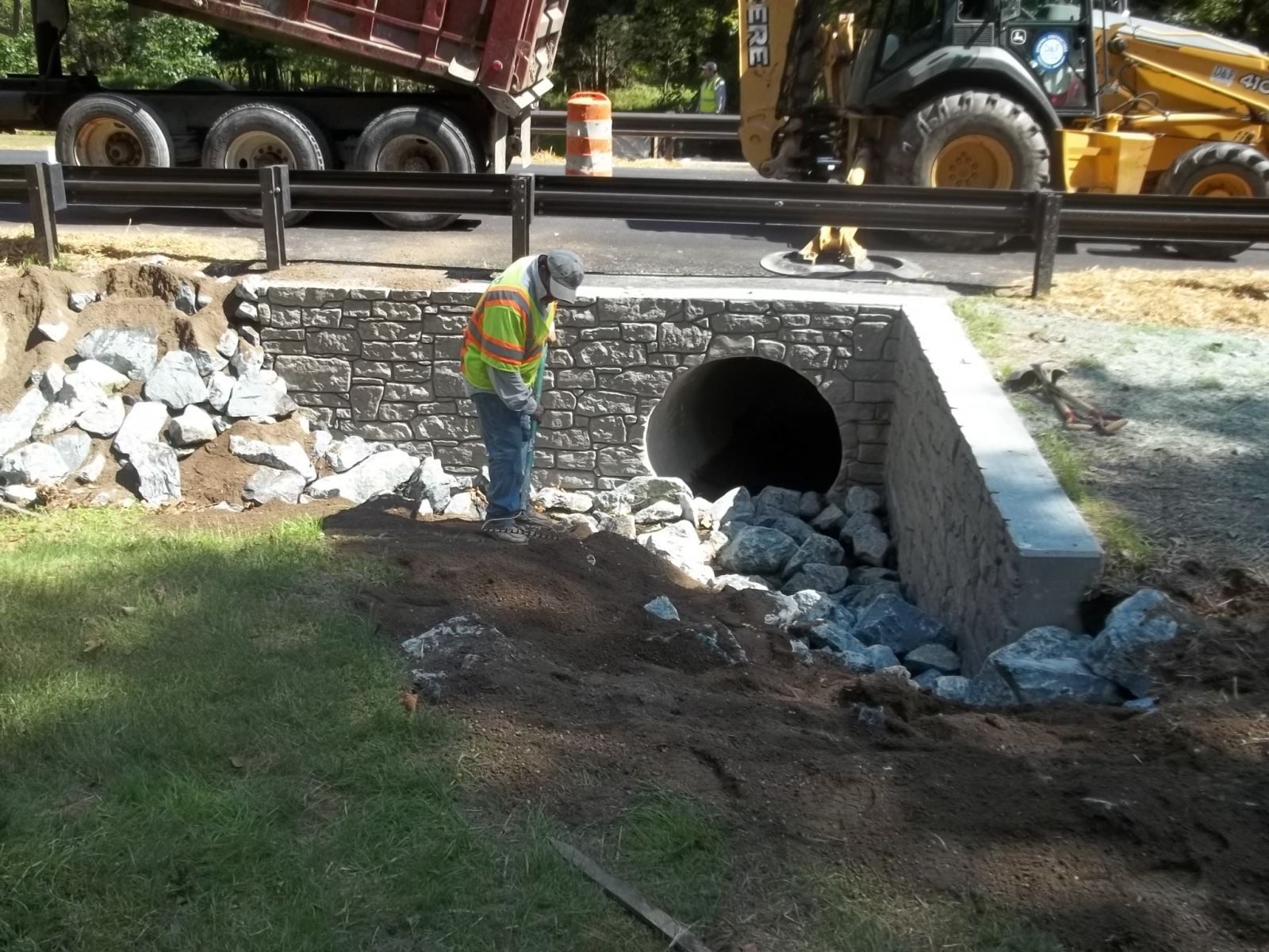
Bridges, Culverts, and Inlets to Waters of the State
Yes! Construction, reconstruction, repair or replacement of bridges, culverts, storm sewers, and inlets to Waters of the State requires a permit.
Bridge and culvert crossings should provide equivalent hydraulic capacity as existing condition; retain existing navigational capacity; not adversely affect water quality; represent the “minimal impact” solution to a specific need with respect to all other alternatives; allow for future erosion, scour, and sedimentation considerations.
Adequate vegetation or other means of shoulder and bank protection must be implemented in order to minimize soil erosion and pollution of water and to protect and reduce the future maintenance.
Permit Application and plan must include:
- Existing and proposed flow line (invert) elevations.
- End details with flared end sections and rip rap (energy dissipaters).
- Size and description of structure.
- Emergency overflow elevation and route.
- Construction schedule.
- Narrative describing construction methods.
- Grading & Erosion-Sediment Control Plan.
- Computations of watershed area, peak flow rates, and discussion of potential effects on water levels above and below the project area.
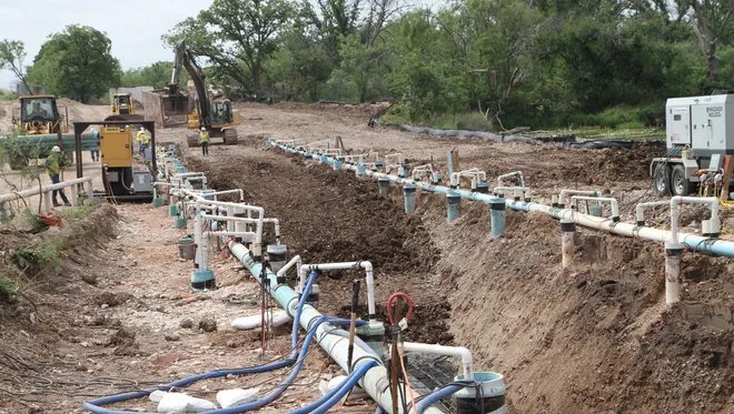
Groundwater Dewatering
Yes! Projects requiring the withdrawal of groundwater (and subsequent discharge) within the jurisdiction of Pelican River Watershed District are subject to permitting. When evaluating the permitting of such projects the District reviews plans to withdraw groundwater and location of the place of discharge.
Permit application and plan must include:
- Grading & Sediment-Erosion Control Plan.
- General description of the situation, impact on receiving body of water, the projected maximum yearly withdrawal, and its use.
The Managers understand their responsibility to maintain Ditches 11, 12, 13 and 14 in accordance with M.S. Chapter 103E and relevant case law. The District also intends to maintain and further develop the ditches in such a way as to minimize their past, present and future downstream impacts on the District’s lakes. The District adopted the MN Buffer Compliance Rule which requires buffers on all public drainage systems.
In addition to any obligations or restrictions described in preceding sections in these Rules copies of a proposal or plan which involves any modification of the Public Drainage systems, or any waterways that impact the discharge or the nutrient loads of those systems, must be provided to the Managers at least 10 days prior to the commencement of work. The notification must contain sufficient information to allow Managers to make an informed judgment on the conformance with provisions of M.S. Chapter 103E, the District Rules, and other applicable rules, statutes and ordinances.
A permit is required for the following items:
- dredging, filling, or diking of watercourses, wetlands or lakes.
- culvert and bridge replacements or modifications.
- variance and conditional use for feedlots within 1000 feet of a waterway.
- streambank stabilization, including the placement of rip rap.
- channelization of watercourses.
- construction of laterals.
- repair of laterals.
- removal of grass, shrubs or trees within 16.5 feet of a watercourse.
- increased discharge to a lateral or ditch as a result of increases in impervious surface.
- storage of snow within 50 feet of a ditch or a lateral.