
Lake Facts
| Floyd (Big and North) | |
|---|---|
| DNR ID/ Becker No | MN03-0387-00/387 |
| Township(s) | Detroit |
| Lake Classification | General Development |
| Ordinary High-Waterline (OHW) | 1354.8' (NGVD29) |
| Size | 862 Acres |
| Shoreline Length | 5.5 miles (Big Floyd) 3.6 miles (North Floyd) |
| Maximum Depth | 26 Ft (Big Floyd) 34 Ft (North Floyd) |
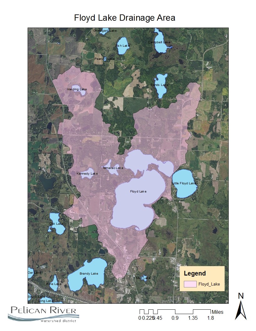
| Watershed Area | 6281.3 Acres |
| Impairment Listings | Mercury |
| Common Fish Species | Walleye, Largemouth Bass, Bluegill, Black Crappie, pumpkin seed and rock bass |
| Invasive Species | Zebra Mussels |
| Public Access/Beaches | Big Floyd SE shore (MN DNR) |
| Land Use | 21.7% Open Water 8.7% Developed 4.9% Wetlands 15.5% Cultivated Crops 31.4% Forest 17.7% Grassland |
Map
Lake Description & Overview
Floyd Lake is located north of the City of Detroit Lakes and contains a heavily developed shoreline. The lake is divided into two distinct basins, known locally as Big Floyd and North Floyd. The lakes are heavily used for game fishing, boating, and other summer and winter recreational activities. The larger of the two basins, Big Floyd, has a littoral area (<15 ft) that accounts for nearly 70% of the lake area, with emergent aquatic plants very common. North Floyd littoral area (<15 ft) coverage is approximately 60%. There is one MN DNR owned public access located on the southeast side of Big Floyd. North Floyd Lake does not have a public access but is accessible via a channel between the two basins.
The major water source into North Floyd is Becker County Drainage Ditch 12/Campbell Creek. There are two minor inlets located on the west side of North Floyd, and the southwest side of Big Floyd. Campbell Creek is an intermittent, high gradient stream and is the major nutrient source to North Floyd Lake. Sections of Campbell Creek were ditched and straightened in the early 1900s for agricultural benefit and included partially drawing down Campbell Lake and draining the surrounding wetland areas. Becker County Ditch 11-12 discharges into Campbell Creek, a natural channel which drops almost 80 feet in 2 miles before reaching North Floyd. Through the lower reach, Campbell Creek flows through highly erodible soils, and carries a heavy sediment load to North Floyd. Generally, Big Floyd also contributes some flow to North Floyd, although it is thought the source of this water is mainly from groundwater. Other minor water sources include overland flows and groundwater seeps and springs.The outflow is located on the east side of North Floyd and connects to Little Floyd through a Becker CSAH21 road culvert.
Both lakes have undergone increased development pressure in the past 15 years. Big Floyd underwent conversions of seasonal cabins to permanent year-round residential homes and increased second-tier development. In 2017, the Ironman Golf Course, located between Big and Little Floyd Lakes was converted to residential lots. Big Floyd’s shoreline is extensively developed with approximately 76% of 300 parcels exhibiting moderate to significant shoreline modification. In the mid-2000’s, the north side of North Floyd was converted from agriculture pasture to residential lots. Since the conversion, approximately 12% of North Floyd’s 67 parcels have moderate to significant shoreline modification. Utilization of rip-rap, vegetation/tree removal, sand blankets and retaining walls are prominent alteration practices.
Residential properties primarily use septic systems, with a few parcels using holding tanks. It is anticipated parts of Big Floyd may be annexed into the City of Detroit Lakes as it is an area identified in the “Future Utility Extension/Annexation Area” of the City of Detroit Lakes Comprehensive Plan. This area is also within the City of Detroit Lakes “extra territorial” 2-mile area, which means the City has influence on the specifics of new developments.
Both Big and North Floyd Lakes are dimictic lakes. Most of the time Big Floyd’s water is clear, with moderate phosphorus and algae concentrations, good game fish populations, and moderate aquatic plant growth. Big Floyd exhibits above average water quality in comparison with other District Lakes and is considered mesotrophic with annual averages of 12.5 feet of water clarity and 18 ppb in-lake phosphorus concentrations. In comparison, North Floyd suffers from poor water clarity, high phosphorus and severe algal blooms as a result of almost 100 years of elevated phosphorus and sediment loading from ditched Campbell Creek. In North Floyd, there is a phenomena occurring known as “internal phosphorus loading” which recycles and releases phosphorus back into the water column causing algae blooms. This is due to decades of legacy phosphorus that has accumulated in the lake sediment. In late summer, after water “turnover”, North Floyd experiences occasional algae blooms caused by the release of phosphorus from the enriched lake sediments. North Floyd is considered borderline eutrophic as the annual average of in-lake phosphorus concentrations have remained in the 32-34 ppb range.
The District partnered with the Natural Resource Conservation Service (NRCS) to develop an Upper Pelican River Watershed Plan and Environmental Assessment (2007) to identity the major sources of nutrients and sediment loading in the Upper Pelican River reach including Campbell Creek and the Pelican River/Ditch 13 area from Little Floyd Lake to Detroit Lake. The plan recommended a strong non-degradation policy for Big Floyd; Campbell Creek short term reductions of 25% TP loading, 50% reductions long-term to North Floyd and to improve North Floyd water quality to 25ppb in-lake concentration to benefit downstream Little Floyd Lake water quality.
The District partnered with NRCS, Becker County Soil and Water Conservation District, and landowners to prioritize and install over 25 agricultural BMPs in the upper Campbell Creek watershed in 2012 and 2013 including terrace/tile structures, stream bank buffers, and wetland restorations (cost share with Federal, State and local funding of over $250,000). While these efforts resulted in reduction in farm field soil erosion, the lower portion of Campbell Creek’s confined stream channel remains highly erodible. However, there has been some improvement in North Floyd annual water clarity in the past decade from 7.5 ft (1998-2007) to 8.5 ft (2008-2017), but no improvement in the phosphorus concentration. Campbell Creek and it’s watershed, continues to be a source of nutrients and sediment to North Floyd Lake, especially during spring runoff and summertime high intensity rainfall events. The District will continue to assess and implement additional measures to reduce external and internal phosphorus inputs and sediment loading into North Floyd Lake. The non-degradation measures for Big Floyd include Stormwater management, shoreline enhancements, and septic treatment.
Water Quality
Big Floyd Lake
North Floyd Lake
Learn More
DNR Lakefinder
Get information on water levels, fish stocking, and depth maps for Floyd.
MPCA Surface Water Data
Find historical water quality data for North Floyd and Big Floyd.
Becker County Coalition of Lake Associations
Goals
Big Floyd Short Term Goals – Year 2025
- Maintain a 5-year mean summer phosphorus concentration at or below 20 μg/L
- Maintain mean summer Secchi depth no less than 10 ft
Big Floyd Long Range Goals – Year 2035
- Maintain a 5-year mean summer phosphorus concentration at or below 15 μg/L
- Maintain mean summer Secchi depth no less than 11 ft
North Floyd Short Term Goals – Year 2025
- Maintain a 5-year mean summer phosphorus concentration at or below 35 μg/L
- Maintain mean summer Secchi depth no less than 8 ft
North Floyd Long Range Goals – Year 2035
- Maintain a 5-year mean summer phosphorus concentration at or below 30 μg/L
- Maintain mean summer Secchi depth no less than 9 ft
Studies & Surveys
Future Surveys as part of 2020-2030 Monitoring Plan
Water Quality- all years
Zooplankton Survey (Performed in collaboration with MN DNR) – All years
Vegetation Survey – 2025
Shoreline Survey – 2026
Past Surveys
Water Quality –1997-2023
Shoreline Survey – 1997, 2004, 2009, 2016
Vegetation Survey – 2011, 2018 (RMB Labs), 2020
For more studies and surveys, see the Floyd-Campbell Water Management Area.