
Characteristics
| Detroit-Rice Planning Area | |
|---|---|
| Watershed area | 25,000 acres |
| Land Use | 7.8% Impervious 36.5% Agriculture 38.2% Forest 14.4% Water 3.1% Wetland |
| Major Lakes | Big Detroit, Little Detroit, Curfman |
| Shallow Lakes | Leitheiser, Schultz, St. Patrick |
| Streams/Public Ditches | Pelican River (Ditch 13), Sucker Creek |
| Impaired On the MPCA Impaired Waters List, Restoration necessary | Pelican River (Ditch 13) |
| Enhance Enhance condition to prevent future impairment. Nearly Impaired/degrading trend. | Big Detroit |
| Protect Maintain good condition and protect against future risks. | Little Detroit, Curfman |
| More information needed for assessment | Leitheiser, Schultz, St. Patrick |
Map
Description & Overview
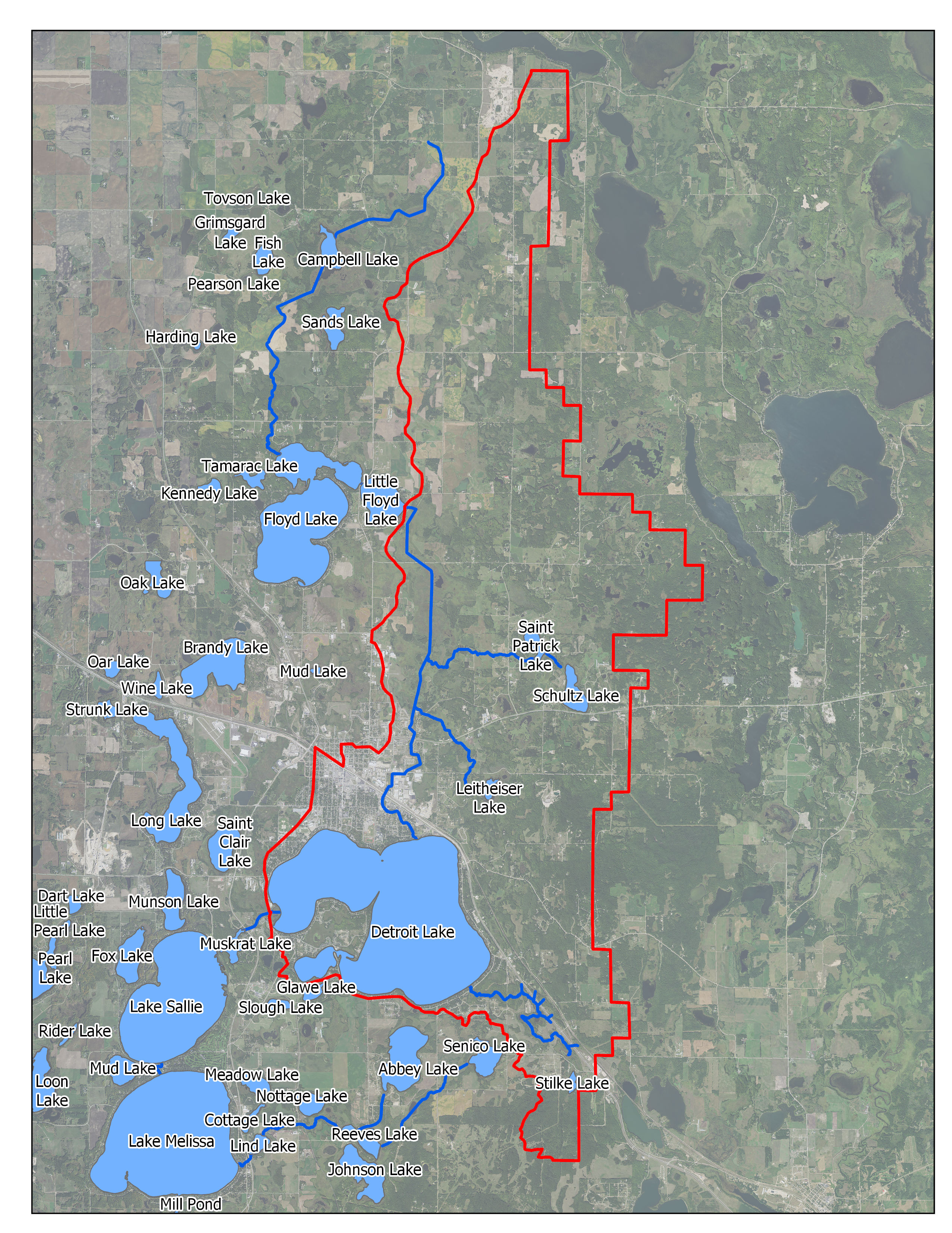
The Detroit-Rice LWQMA consists of approximately 25,000 acres, including the City of Detroit Lakes (Figure 5-3). The main water bodies in the LWQMA are Detroit Lake (locally split into Big Detroit, Little Detroit and Curfman Lakes) and the Pelican River (Ditch 13), and Rice Lake Wetland. There are also smaller waterways, including Sucker Creek (a trout stream) and several private ditches, as well as smaller lakes, including Saint Patrick, Schultz and Leitheiser Lakes.
Extensive shoreline alteration over the past 75 years has attributed to this increase of impervious land-cover around Detroit Lake. Originally lined with summer cottages and resorts, nearly all of the properties around Detroit Lake are now used for year-round purposes, and most resorts have been converted to commercial or high-density residential uses. The shorelines of Saint Patrick, Schultz and Leitheiser remain largely undeveloped.
Comprised of two main basins, Big and Little Detroit, Detroit Lake accounts for 85 percent of the surface water of the Detroit-Rice LWQMA. The remaining lakes consist of Curfman Lake which is connected to Big Detroit, but is considered a separate lake, and shallow lakes Saint Patrick, Schultz and Leitheiser Lakes, which relatively little is known about. Big Detroit is much bigger and deeper than Little Detroit. Both are heavily used for a broad range of summer and winter recreational activities. Big and Little Detroit Lakes enjoy relatively good water quality. Big Detroit has worse water quality than Little Detroit, exhibiting mid-summer episodes of moderate to severe algae blooms. This is in part because Big Detroit receives large phosphorus loads from the Pelican River, which inlets directly into Big Detroit after draining Rice Lake Wetland and the Detroit Lake industrial park, among other areas. There is some evidence that Big Detroit’s water quality may also be worsened by internal loading, but this needs to be further investigated. Untreated urban Stormwater runoff from Detroit Lakes likely also contributes to Big Detroit Lake’s phosphorus load. Little Detroit Lake has exhibited some improvement over the last decade, presumably because sanitary sewer lines (versus septic systems) now serve almost all lakefront properties, and because most untreated Stormwater runoff has been diverted.
The Pelican River runs through Rice Lake Wetland and is also known as Ditch 13 in the Detroit-Rice LWQMA. High E. coli levels have been found in the Pelican River recently between Highway 34 and North Shore Drive. E. coli sources to the Pelican River should be investigated. The Pelican River is impaired for high E. coli loads, low dissolved oxygen, and low fish and invertebrate bioassessment scores.
Big and Little Detroit Lakes are both impacted by the presence of aquatic invasive species and nuisance growth of native plant species. Currently there are four known aquatic invasive species present in Detroit and Curfman Lakes: Flowering rush, Curly-leaf pondweed, Zebra mussel, and Chinese mystery snails. A native algae species, Chara, also grows in thick beds in some shallow areas, causing boating and swimming issues. While the District is successfully controlling the nuisance and invasive vegetation (i.e., Flowering rush, Curly-leaf pondweed, Chara) with herbicides (the District found harvesting was exacerbating the spread of flowering rush), Chinese Mystery snails and Zebra mussel populations are greatly increasing.
Water Quality
Pollutant/Stressor
Phosphorous
Focus
Tributary- Rice Lake Loading
Goals
- Decrease Tropic Index of Big Detroit by 5%
- Maintain improvements in Little Detroit’s water quality
Actions
- Manage phosphorous loading from Rice Lake Wetland Complex by completing the wetland restoration project.
- Investigate and manage internal loading in Detroit Lake.
- Treat Stormwater discharges through implementation of District Rules.
- Manage quality of upstream lakes and streams.
- Identify and protect sensitive aquatic areas
- Conduct shoreline surveys
- Lakeshore protection through implementation of District Rules.
Pollutant/Stressor
Impairments:
- Bacteria
- Low dissolved oxygen
- fish bioassessments
- invertebrate bioassessments
Focus
Nearshore- E.coli loading
Goals
Manage TMDL’s on the Pelican River
Actions
- Investigate sources of E.coli in upland sources.
- Explore opportunities to implement stream restoration BMP’s
- Encourage development of diverse vegetation and geomorphology in the Pelican River
- Complete the Rice Lake Wetland Restoration
Water Quantity
Pollutant/Stressor
N/A
Focus
N/A
Goals
Promote shorelines resilient to fluctuating water levels
Actions
Promote conversion to naturalized shorelines
Pollutant/Stressor
N/A
Focus
N/A
Goals
Ensure sustainable groundwater supply
Actions
Encourage installation of BMP’s that increase infiltration.
Ecological Integrity
Pollutant/Stressor
- Climate change
- Transportation of AIS
- Habitat fragmentation and degradation
Focus
- AIS
- Wildlife Habitat
- Fish communities
Goals
- prevent establishment of new invasive species, and manage existing invasive species.
- Protect and improve wildlife habitat in near shore areas
- Maintain healthy fish communities.
Actions
- Develop readiness response plan
- Monitor access points for new AIS
- Continue to treat AIS infestations
- Continue to research new methods to manage AIS
- Perform periodic aquatic vegetation surveys
- Encourage pollinator friendly seed mixes and plantings
- Identify and protect sensitive aquatic Areas