
Characteristics
| Small Lakes Planning Area | |
|---|---|
| Watershed area | 11,000 acres |
| Land Use | 1.7% Impervious 31.7% Agriculture 48% Forest 10.7% Water 7.9% Wetland |
| Major Lakes | Meadow, Johnson, Reeves |
| Shallow Lakes | Abbey, Senical, Lind, Nottage, Cottage, Candor, Glawe |
| Streams/Public Ditches | N/A |
| Impaired On the MPCA Impaired Waters List, Restoration necessary | N/A |
| Enhance Enhance condition to prevent future impairment. Nearly Impaired/degrading trend. | Abbey, Lind |
| Protect Maintain good condition and protect against future risks. | Johnson, Reeves, Meadow, Glawe |
| More information needed for assessment | Nottage, Cottage, Candor, Cooks |
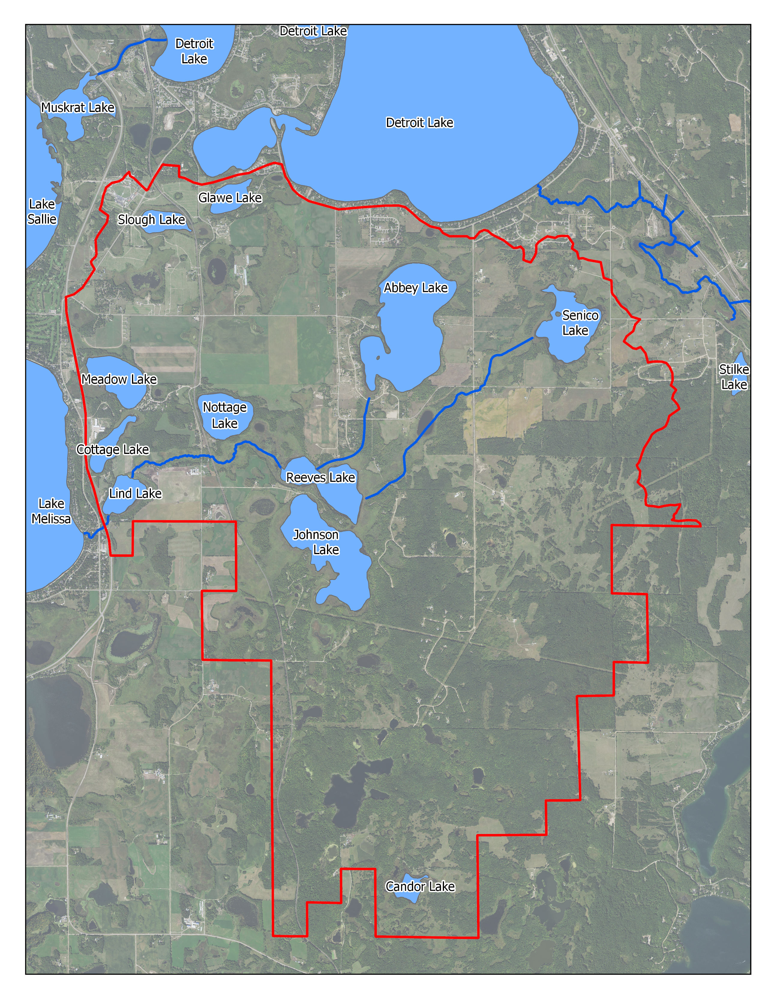
Map
Description & Overview
The Small Lakes WMA consists of about 11,000 acres in the southeastern corner of the District. This WMA extends into Otter tail County and contains numerous small lakes and wetland areas. Lakes within this area include Johnson, Reeves, Abbey, Meadow, Lind, Nottage, Senical, Cottage, and Glawe. Many of the lakes are connected by means of wetlands, and the overall drainage of the area is indistinct. Land use in this WMA can be roughly divided into the northwest half and the southeast half. The northwest half of the WMA contains significant agricultural areas, as well as most of the lakes and wetlands in the WMA. The southeast half of the WMA is mostly forested with steep slopes. Less than 2 percent of the WMA is covered by impervious surface, and most lakes have relatively high watershed to lake ratios. The shorelines of the lakes in this WMA are sparsely settled but have recently seen more development interest. Johnson and Reeves Lakes have experienced some development pressures. The north area of Reeves Lake was recently platted for residential development. However, the lot sizes are large and have significant wetland shoreline fringes.
Water quality data has been collected since 1998 for Abbey, Meadow, Johnson and Reaves Lakes. Water quality data was collected for Glawe in 2006 through 2009, 2013 and 2017. These lakes all exhibit good water quality, with Abbey being the exception. Abbey is shallow and has been impacted by agricultural practices in the past. That said, in 2018 Abbey’s water quality was substantially improved from past years, although the cause of this change is unknown.
Lind Lake was monitored in 2015 and in 2018 and according to the data, does not have good water quality. It is suspected that agricultural land use, cattle grazing and internal sediment loading area all contributing to poor overall water quality conditions. Lind drains into Melissa Lake in the Sallie-Melissa WMA. Meadow Lake is of special interest because of it is very deep, possessing a maximum depth of 72 feet. Meadow Lake has very good water quality and is a designated trout lake. There is some development on the lake, including a resort.
Water Quality
Pollutant/Stressor
Phosphorous
Focus
Nearshore
Goals
Protection- Adaptatively manage to protect, enhance, and restore water quality
Actions
- Identify and target critical Agricultural erosion areas
- Identify and protect sensitive aquatic areas
- Explore impacts of gravel mining in the WMA
- Treat stormwater discharges through the implementation of District Rules
- Conduct Shoreline Surveys
- Explore Forest Stewardship Plans
- Explore effects of Irrigation on Abbey Lake
- Manage Stormwater Runoff through implementation of District Rules
Pollutant/Stressor
Phosphorous
Focus
Nearshore
Goals
Protection- Adaptatively manage to protect, enhance, and restore water quality
Actions
- Identify and target critical agricultural erosion areas
- Identify and protect sensitive aquatic areas
- Treat stormwater discharges through the implementation of District Rules
- Conduct Shoreline Surveys
- Explore a Forest Stewardship Plan
- Explore effects of Irrigation on Johnson/Reeves
- Lakeshore Protection through implementation of District Rules
Pollutant/Stressor
Phosphorous
Focus
Nearshore
Goals
Protection- Adaptatively manage to protect, enhance, and restore water quality
Actions
- Identify and target critical agricultural erosion areas
- Identify and protect sensitive aquatic areas
- Treat stormwater discharges through the implementation of District Rules
- Conduct Shoreline Surveys
- Explore effects of Irrigation on Meadow
- Lakeshore Protection through implementation of District Rules
Pollutant/Stressor
Phosphorous
Focus
Nearshore
Goals
Protection- Adaptatively manage to protect, enhance, and restore water quality
Actions
- Identify and protect sensitive aquatic areas
- Treat stormwater discharges through the implementation of District Rules
- Conduct Shoreline Surveys
- Lakeshore Protection through implementation of District Rules
Pollutant/Stressor
N/A-Insufficient Data
Focus
N/A-Insufficient Data
Goals
Acquire Baseline Data
Actions
- Sample water quality on shallow lakes as opportunity arises.
Water Quantity
Goals
Promote shoreline resilient to fluctuating water levels
Actions
- Promote conversion of seawalls to naturalized shorelines
Goals
Ensure sustainable groundwater supply
Actions
- Encourage installation of BMP’s that increase infiltration
Ecological Integrity
Pollutant/Stressor
- Climate Change
- Transportation of AIS
- Habitat Fragmentation and Degradation
- Loss of habitat connectivity
Focus
- AIS
- Wildlife Habitat
- Fish Communities
Goals
- Prevent establishment of new invasive species and manage invasive species that are present.
- Protect and Improve wildlife habitat in near shore areas.
- Maintain healthy fish communities.
Actions
- Develop readiness response plan
- Perform periodic aquatic vegetation surveys
- Encourage pollinator friendly seed mixes and plantings
- Identify and protect sensitive aquatic Areas
- Assist MN DNR with replacing weir on Little Floyd Lake Dam with rock rapids