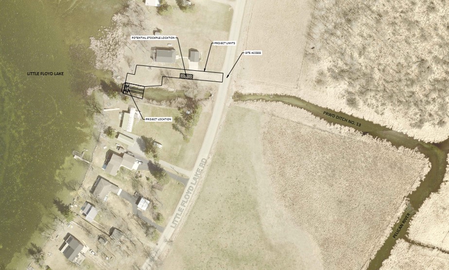
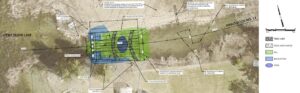
Project Purpose
The existing Little Floyd Lake dam was constructed in 1936 and acts as a barrier to fish migration upstream into Little Floyd Lake, the headwaters of the Pelican River. The existing dam will be modified and provide fish passage by installing a rock arch rapids which will improve opportunities for recreation, fish and wildlife habitat and dispersal, as well as provide a permanent fix to the aging fish barrier structure. A complete replacement of the dam would cost much more than retrofitting the existing dam structure. The project will maintain the existing hydraulic function while helping to improve biodiversity and aquatic habitat both upstream and downstream of the proposed rock arch rapids design. The project will improve the connectivity of the rivers and streams in the region and, consequently, will improve fish movement through the Red River basin system. Aquatic species benefiting include all fish and mussel species of the upper Pelican River.
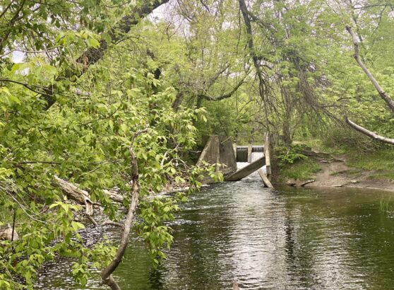
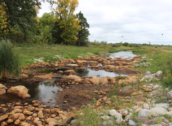
What is a Rock Arch Rapids?
A rock arch rapids is a structure that mimics shallow natural rapids in rivers that can be traversed by fish moving up and downstream. While modification of the dam into rock arch rapids will benefit all aquatic species moving along the channel, this structure will be particularly useful in aiding the MN DNR’s goal of reintroduction of sturgeon, the MN DNR began stocking them in downstream Detroit Lake in 1997, and the rock arch rapids would create suitable spawning habitat for them.
In addition, this project will aid in improved fish movement and reproduction as outlined in the MN DNR’s Red River of the North Fisheries Management Plan (2017-2027) and the Pelican River Watershed District Revised Water Management Plan (2020-2029). Even though this project covers less than one acre of land, it will benefit the 14,790 acres of lakes and 84 river miles in the entire Pelican River Watershed by restoring connections that existed prior to dam building.
Project Benefits
This project will benefit the 14,790 acres of lakes and 84 river miles in the entire Pelican River Watershed by restoring connections that existed prior to dam building. To date, 40 barriers to fish migration have been eliminated in the Red River of the North Watershed, and this would be one more important addition. While modification of the dams into rock arch rapids will benefit all aquatic species moving along the channel, this structure will be particularly useful in aiding the MN DNR’s goal of reintroduction of sturgeon throughout the state.
The MN DNR sturgeon reintroduction program has already had significant state investments in funding and resources to improve fish movement and reproduction outcome goals outlined in the MN DNR Red River of the North Fisheries Plan. The MN DNR began stocking sturgeon in Detroit Lake in 1997, and the Little Floyd Lake Rock Arch Rapids would be a key component in creating suitable spawning habitat for sturgeon in the northern portion of the Pelican River Watershed District.
In summary, the main objective of this project is to modify the current Little Floyd Lake dam into a rock arch fishway, thereby providing a long-term fix to the aging dam/fish barrier which will provide multiple benefits:
(a) improve the functionality of the outlet
(b) provide easier dispersal for river species upstream and downstream
(c) provide spawning substrate for sturgeon and other fish species.
Questions About Lake Levels
Will my lake level change as a result of this project?
No. Your lake is a designated public water. That means the runout elevation and performance of the dam will be maintained by any replacement structure. This is a Minnesota statutory requirement. A consulting engineer has submitted modelling as part of project permitting, demonstrating compliance with this requirement. Similar projects have been implemented in a wide diversity of locations around the state and are designed by professional engineers contracted specifically for the work. Lake levels have not been impacted by these projects. In the simplest sense, we replace one weir (dam) with another (top step of the rock-arch rapids) that maintains the critical dimensions and runout elevation. There are many local examples of similar projects, including Muskrat, Pelican, Lizzie, Prairie, Little Pine, Big Pine, Rush, and Otter Tail Lakes
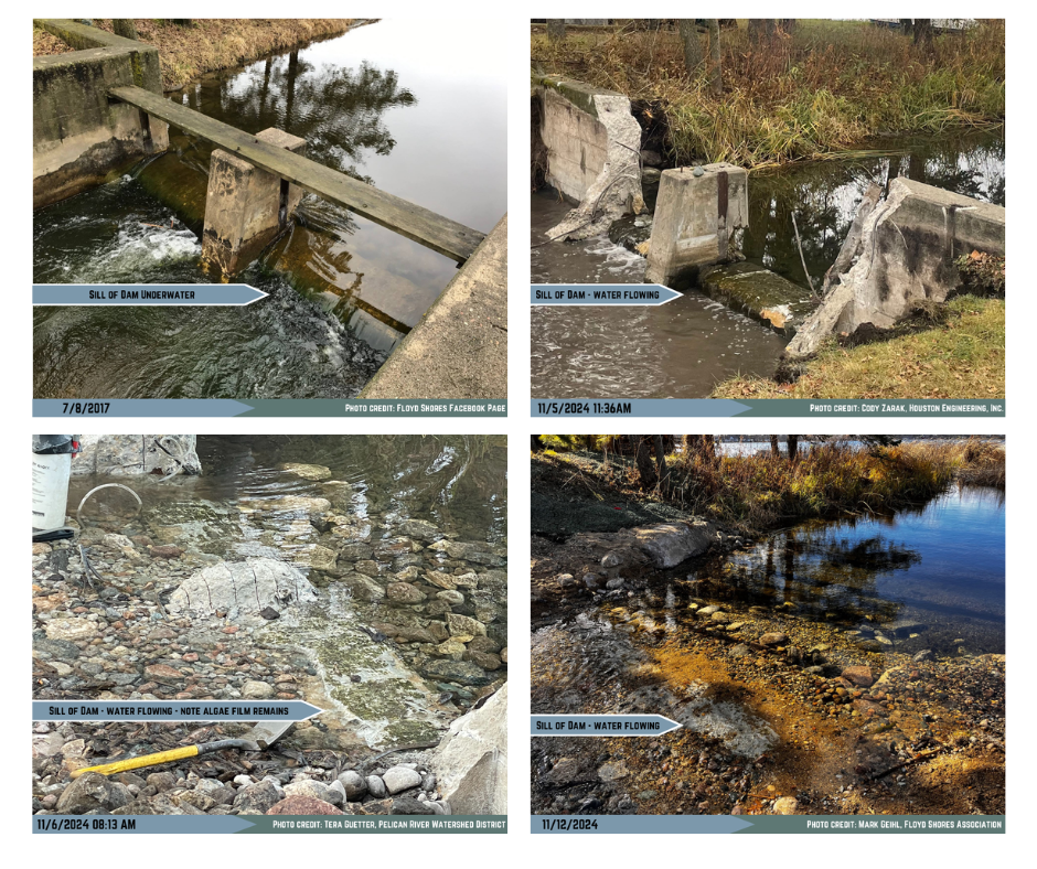
Per project design plans, the dam sill was not removed during construction. The existing dam sill and the first downstream bolder weir maintain the original dam elevation of 1355.0 NAVD 1929 as authorized by the Dam Safety Program.
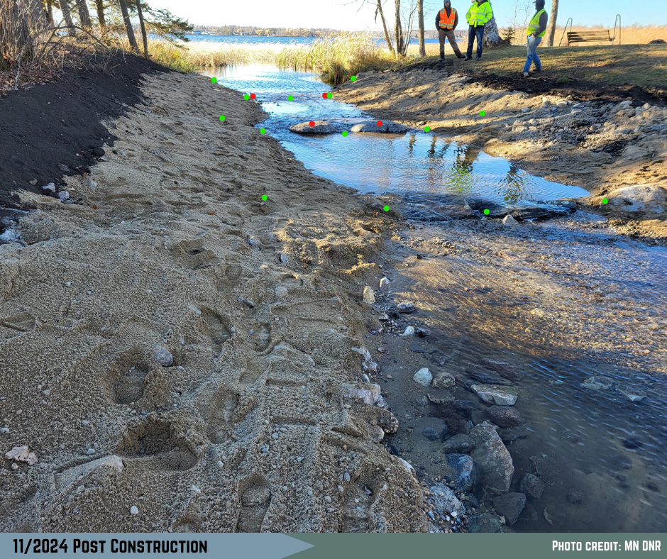
 How can the project move from a box-like rectangular cross section of concrete walls to an open channel trapezoidal cross section, yet have similar water behavior over the dam?”
The project post-construction runout elevation and hydraulic performance must be maintained. Hydraulic performance is the amount of water leaving the lake at a full range of upstream high and low levels using historical lake level data. Performance is influenced by outlet runout elevation (legally fixed, red dots), channel geometry (see photo with green dots, simplified for example), downstream channel geometry, and the road culvert geometry/elevations. Prior to project permitting, all of these factors are placed into a flow model, simulating the new structure. The performance of the new structure is iteratively improved. Channel dimensions (green dots) are altered to ensure that the performance of the new matches performance of the old.
Construction Phase Water Levels
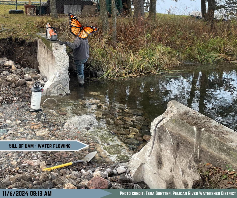
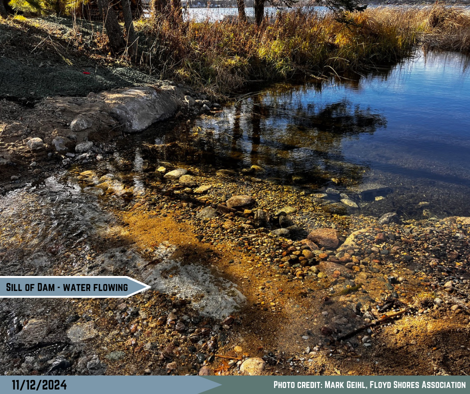
Construction Lake Level Monitoring – 11/4/2024 to 11/8/2024.
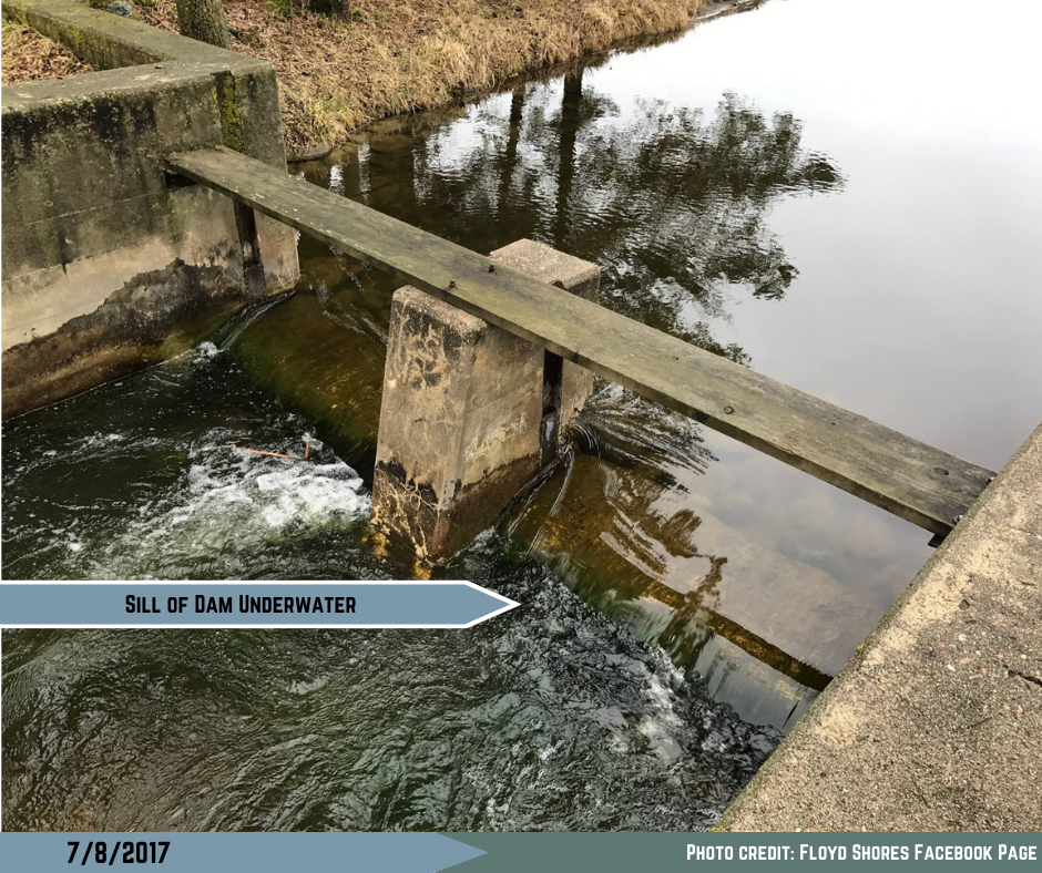
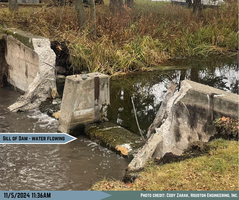
Lake levels were recorded and pictures were taken AM and PM during construction to verify lake levels throughout the construction. The staff gauge photos demonstrate pre- and post-project lake elevations were/are the same. Note the water flowing over the dam sill pre and post construction.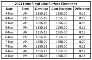
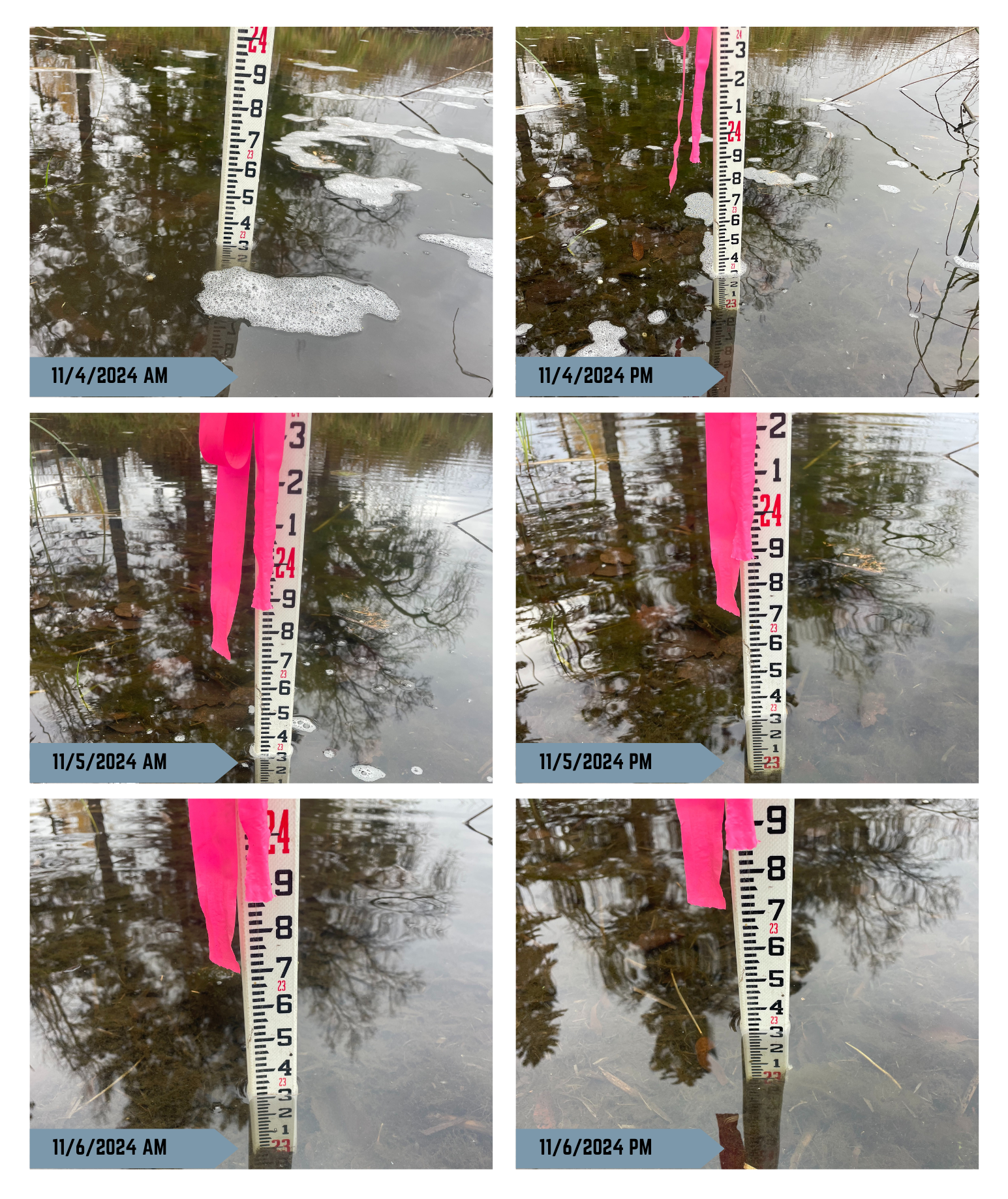
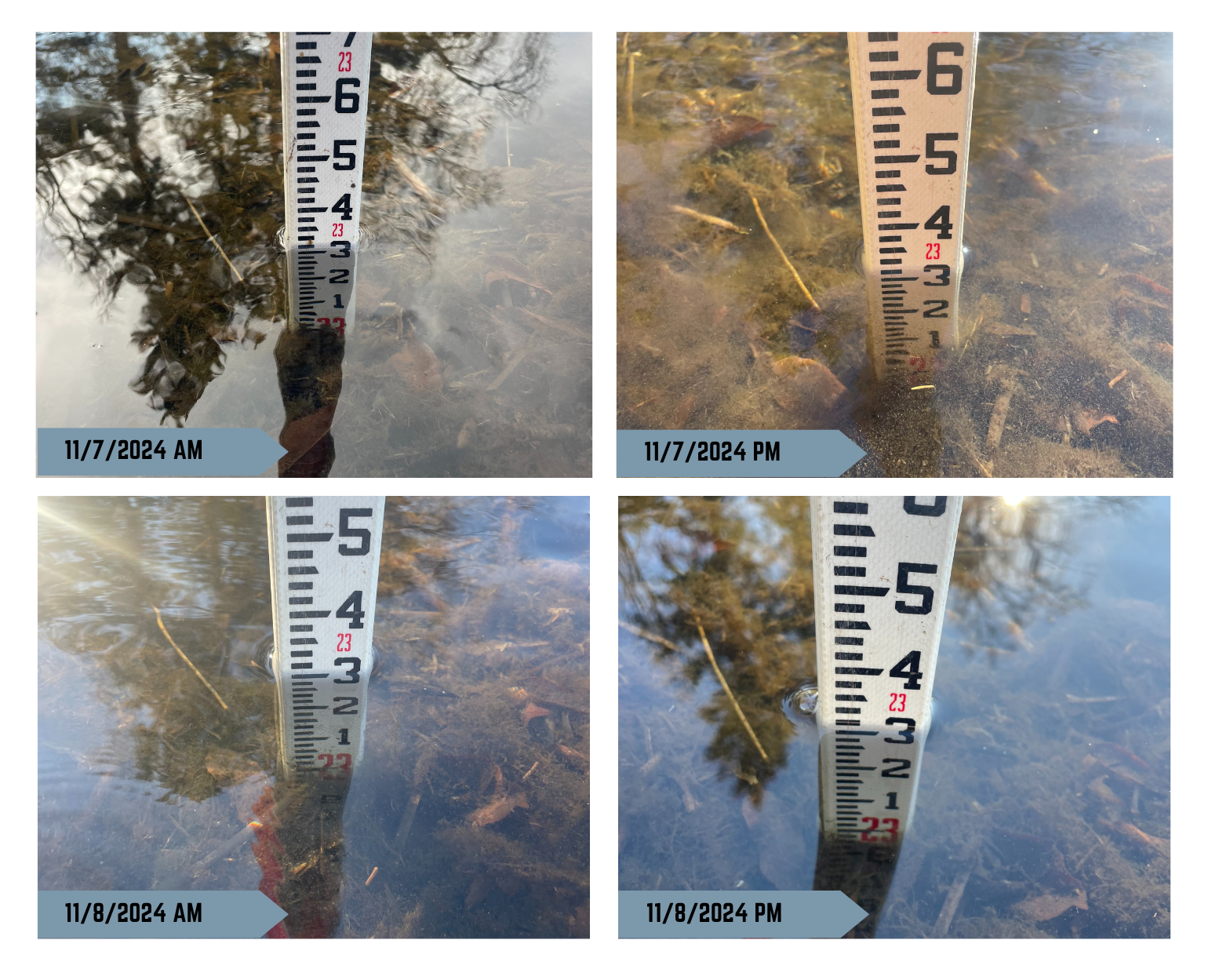
Per project design plans, the dam sill was not removed during construction. The existing dam sill and the first downstream bolder weir maintain the original dam elevation of 1355.0 NAVD 1929 as authorized by the Dam Safety Program.
Construction Progress
Project Funding
The Pelican River Watershed District received grant funds to construct this project.
MN DNR Grant – $ 156,400 (Clean Water Land and Legacy; Conservation Partners Legacy)
PRWD Local Funds Match – $18,000
Project Total = $174,400
Thirty-three percent of the sales tax revenue from the Clean Water, Land and Legacy amendment is distributed to the Outdoor Heritage Fund. Those funds “may be spent only to restore, protect, and enhance wetlands, prairies, forest and habitat for fish, game, and wildlife.” Land acquired with Outdoor Heritage Funds must be open to public hunting and fishing during the open season in accordance with the state constitution.

![]()
![]()